


The Council recognizes that the Columbia River Basin is an immense system that encompasses a vast array of physical, biological, and human elements. The program recognizes that because of the size and complexity of this system, the basin usually is managed as a collection of individual components. However, the Act directs the Council to view the river as a single system in its planning. Managing the river as a system means recognizing its structure and how the parts work together. The program also recognizes the Pacific Ocean as an integral component of the Columbia River ecosystem and includes a strategy for the ocean and freshwater plume.
The program is organized into four nested levels that make up its geographic structure and emphasize the relationships among the framework elements. The four levels are:
- Basinwide: This level addresses the entire Columbia River Basin of about 259,000 square miles, including the plume and nearshore ocean. Basinwide guidance contains the program vision, scientific foundation, biological objectives, strategies, and implementation provisions that apply generally across the program and are implemented throughout the basin. This level represents management occurring at the landscape scale.
- Mainstem: In this program, “mainstem” refers to the main channels of the Columbia and Snake rivers. The program includes a mainstem strategy with specific objectives and actions for the federal operating agencies and others to implement in the mainstem Columbia and Snake rivers to protect, mitigate, and enhance fish and wildlife affected by the development and operation of hydroelectric dams.
- Subbasins: This level represents geographic units of hundreds and in some instances thousands of square miles. Subbasins include tributaries of the main Columbia and Snake rivers and also distinct sections of the mainstem rivers. The program includes 62 subbasins, as shown in Figure 3, 59 of which have subbasin plans and are a significant portion of the Council’s Columbia River Basin Fish and Wildlife Program. These plans contain specific objectives and measures that guide actions that implement the program.
- Other geographic scales: Other geographic-scale units comprising adjoining subbasins with similar terrain and biological communities may be used by the Council as geographic organizing tools to reference particular areas of the basin, or to review work occurring specifically in those areas. The Council may continue to use these organizing units as well as Evolutionarily Significant units (ESUs) for listed anadromous fish, or other common geographic reference areas or management units to conduct its work, as appropriate.
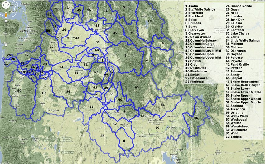
Figure 3. Columbia River Basin Fish and Wildlife Program Subbasins.