


Grande Ronde Model Watershed Project Highlights Strength of Community-Managed Actions
- August 25, 2023
- Carol Winkel
Jesse Steele, executive director for the Grande Ronde Model Watershed Project, which is funded through the Council’s fish and wildlife program, gave an update on its accomplishments. It’s one of seven umbrella projects supported by the Council’s fish and wildlife program.
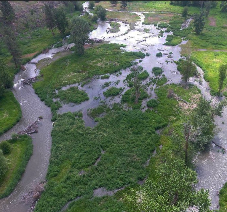
Located in the Grande Ronde River and Imnaha River subbasins of Northeastern Oregon, the project’s watershed restoration activities focus on habitat protection and restoration for salmon and steelhead and other native fishes, while supporting land and water management.
The area covers over 5,000 square miles of land and over 4,000 stream miles of salmonid habitat in Oregon’s Union and Wallowa Counties, as well as a portion of Asotin County, Washington. About 54 percent of the Grande Ronde Subbasin and 30 percent of the Imnaha Subbasin are privately owned.
Established in 1992, the Grande Ronde River was selected by the Council as the model watershed project in Oregon. It is managed by local representatives and agency personnel involved with multiple uses of natural resources within the basin.
As a model watershed, it serves as an example of management partnerships among local residents, state and federal agency staff, and public interest groups. By improving coordination and community involvement, efforts to restore fish and wildlife habitat and improve water supply and quality have a better chance for sustainable success.
Steele highlighted recent projects funded by GRMW and implemented by partners:
- Upper Grande Ronde River Bowman Project (ODFW) and Middle Upper Grande Ronde River Restoration (CTUIR), which introduced trees and woody debris into the river via helicopter to increase habitat complexity and increase floodplain connection
- Sheep Creek Restoration (TU), which introduced smaller, woody debris into the river and used locally derived gravels to fill incised channel reaches.
- Wallowa River Wilson-Haun Restoration (TU), which reconnected historic channels and side channels to the river by partially filling the main channel with wood and gravel.
Other work includes technical assessments on fish predation and water quality.
Steele noted that levels of copper in the water varies a lot with some exceedances measured, which needs to be examined more closely. He said it did not seem to be associated with mining and dredging, but that a study was warranted.
Summing up, when asked about mimicking natural landslides, Steele said that while there is much to do to improve habitat, the fish do surprisingly well with some level of disturbance. The fish seem to key in on new or disturbed gravel.
“It’s definitely something we’re looking into,” he said. “Rivers don’t need to look like a park, they should be messy and complex.