


Local strategies, actions achieve results in the Willamette and John Day watersheds
- July 17, 2024
- Carol Winkel
The Council’s Columbia River Basin Fish and Wildlife Program emphasizes local coordination in efforts to improve fish and wildlife habitat. The program’s “umbrella projects” are a prime example of that emphasis on partnerships. At its July meeting, Council members heard about the work being done in the Willamette and John Day watersheds by two such projects.
Eric Williams, grant program manager and Denise Hoffert, partnerships coordinator for the Oregon Watershed Enhancement Board gave an update on the Willamette Bi-Op Habitat Restoration Project. The project uses structured and science-based decision tools to enhance implementation of on the ground activities, and formulate priorities for action.
The Willamette River flows through the Willamette Valley, which lies between the Cascade Mountain Range to the east and the Coast Mountain Range to the west and is fed by numerous rivers and streams originating in the Cascade and Coast Mountain Ranges. It’s the 13th largest river in the contiguous United States in terms of streamflow.
Since the late 1800s, development throughout the Willamette Valley has dramatically altered the form and function of the river, its tributaries, and floodplains. The project is working to increase and enhance habitat for ESA-listed spring Chinook salmon and steelhead in the Willamette and below the major federal dams in the McKenzie River, North and South Santiam Rivers, and Middle Fork Willamette River. The project was developed to meet the requirements of Reasonable and Prudent Actions (RPA 7.1.2 and 7.1.3) of the Willamette Project Biological Opinion. The program is administered by the Oregon Watershed Enhancement Board, which is a state grant-making agency, in partnership with the Bonneville Power Administration.
Its goals include increasing channel complexity and length; improving connectivity between the river and its floodplain; and expanding and improving the health of floodplain forests.
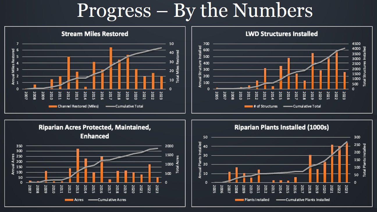
From 2008 to 2023, over 130 projects have been completed; more than 5,200 acres of floodplain and riparian forest have been restored; more than 23 miles of side channels have been enhanced; more than 450 acres of floodplain have been reconnected; and .33 miles of retaining barriers have been modified.
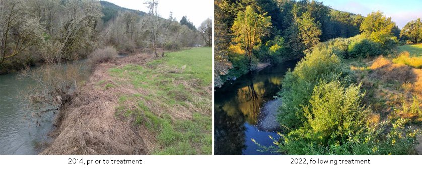
The Luckiamute State Natural Area Project is a good example of the dramatic results of its work.
Stefan Kelly, watershed restoration coordinator for the Confederated Tribes of the Warm Springs Reservation of Oregon gave an update on the accomplishments of the John Day Watershed Restoration Project. The project is implementing actions to protect and restore passage, flow, and habitat for anadromous fish and listed species in the John Day River Subbasin.
The John Day River is the third longest undammed river in the western United States and the longest free-flowing river with wild salmon and steelhead in the Columbia River Basin. It flows 284 miles from its source to its confluence with the Columbia River upstream from the John Day Dam.
The subbasin supports wild runs of spring Chinook salmon and summer steelhead in the upper areas and the lower mainstem supports limited fall Chinook salmon. Pacific lamprey, westslope cutthroat trout, redband trout, bull trout, and western brook lamprey are also part of the ecosystem.
One example of the project’s work is the Vincent to Vinegar Instream Restoration Project, which has protected 71 acres with fencing; installed 49,301 plants; removed about one mile of railroad grade that constricted the Middle Fork John Day River; created about 150 pools; created 0.96 miles of main channel; created 2.23 miles of side channel; filled 0.65 miles of channel; and installed over 1,700 pieces of wood and 8,320 feet of willow trenches.
Other projects under development are the 6 Mile Creek Restoration; Belshaw Creek Phase I; Cottonwood Creek Restoration; Oxbow Phase 6; Caribou Creek Reconnection; Rock Creek Diversion; Indian Creek Diversion; Phipps Meadow Restoration; Fox Creek Reach 9; Mainstem Forrest Conservation Area Restoration; and Dunstan Conservation Area Restoration.
More Information